-
Weather
Remote Weather Stations
National Weather Service
This avalanche advisory is provided through a partnership between the Tahoe National Forest and the Sierra Avalanche Center. This advisory covers the Central Sierra Nevada Mountains between Yuba Pass on the north and Ebbetts Pass on the south. Click here for a map of the forecast area. This advisory applies only to backcountry areas outside established ski area boundaries. This advisory describes general avalanche conditions and local variations always occur. This advisory expires 24 hours after the posted time unless otherwise noted. The information in this advisory is provided by the USDA Forest Service who is solely responsible for its content.
This Avalanche Advisory was published on April 18, 2009:
|
April 18, 2009 at 6:53 am |
|
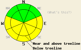
This morning the avalanche danger is LOW. Areas of MODERATE avalanche danger should quickly develop due to daytime warming on E-SE-S-SW-W aspects 37 degrees and steeper at all elevations today. |
|
|
|
Forecast Discussion:
The high-pressure ridge should bring even warmer temperatures to the forecast area today. Temperatures should continue climbing gradually through the weekend. Clear sunny skies and light easterly winds should accompany this warm weather.
Observations near Incline Lake Peak, Rose Knob Peak (both in the Mt. Rose area), and on Jake's Peak (on the West Shore) all showed a mix of soft, unconsolidated snow, sun crusts, wind-scoured areas, and firm wind slabs on the NW-N-NE aspects above 8000'. Between 7500' and 8000' on Jake's Peak, melt-freeze conditions existed on most aspects. Below 7500' on Jake's Peak, snow had completely melted off some areas leaving behind exposed patches of bare ground. On the southerly aspects in both these areas, melt-freeze snow existed. By 11 am the top 2-4 inches of snow had softened.
Even though overnight lows stayed a few degrees above freezing in most areas, the clear skies should have allowed the snowpack to radiate enough heat into the atmosphere for a decent overnight refreeze to occur. This frozen snow should melt and soften quickly today due to warm daytime temperatures and the intense April sun. This melting will produce free water in to the snowpack which will weaken the snowpack by dissolving the bonds between the snow grains. Enough warming and melting could occur for human-triggered surface wet snow instabilities like roller balls, pinwheels, and small point-release avalanches to be possible today. The most likely areas for these instabilities will be on steep, sun-exposed, E-SE-S-SW-W aspects. Well established drainage channels that prevent free water from saturating any one layer in the snowpack should keep wet-slab avalanches unlikely; however, they are not impossible. Plan to be off of any sun exposed slopes before they get too soft and wet. Use observations of surface wet snow instabilities and simple tests like stepping into the snow (if you sink into wet snow above your ankles it is a good time to move to a different slope) to help determine when a slope has become unsafe.
The bottom line:
This morning the avalanche danger is LOW. Areas of MODERATE avalanche danger should quickly develop due to daytime warming on E-SE-S-SW-W aspects 37 degrees and steeper at all elevations today.
Andy Anderson - Avalanche Forecaster, Tahoe National Forest
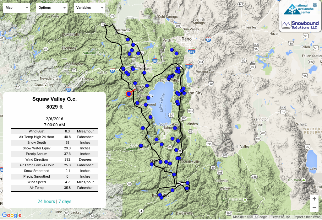
Weather Observations from along the Sierra Crest between 8200 ft and 8800 ft:
| 0600 temperature: | 33-38 deg. F. |
| Max. temperature in the last 24 hours: | 51 deg. F. |
| Average wind direction during the last 24 hours: | East - northeast |
| Average wind speed during the last 24 hours: | 15 mph |
| Maximum wind gust in the last 24 hours: | 28 mph |
| New snowfall in the last 24 hours: | O inches |
| Total snow depth: | 134 inches |
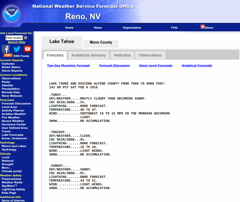
Two-Day Mountain Weather Forecast - Produced in partnership with the Reno NWS
For 7000-8000 ft: |
|||
| Saturday: | Saturday Night: | Sunday: | |
| Weather: | Sunny | Clear | Sunny |
| Temperatures: | 50-57 deg. F. | 31-37 deg. F. | 54-61 deg. F. |
| Wind direction: | East | East | East |
| Wind speed: | 10 mph | 10 mph | 10 mph |
| Expected snowfall: | O in. | O in. | O in. |
For 8000-9000 ft: |
|||
| Saturday: | Saturday Night: | Sunday: | |
| Weather: | Sunny | Clear | Sunny |
| Temperatures: | 48-54 deg. F. | 32-38 deg. F. | 51-57 deg. F. |
| Wind direction: | East | East | East |
| Wind speed: | 10-15 mph with gusts to 25 mph in the morning | 10 mph with gusts to 25 mph after midnight | 10 mph |
| Expected snowfall: | O in. | O in. | O in. |